Home /
Naturtejo UNESCO Global Geopark /
Fraga de Agua d’Alta Waterfall, Orvalho (nearby)
Fraga de Agua d’Alta Waterfall, Orvalho (nearby)
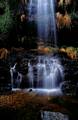
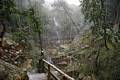
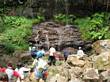
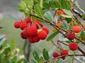
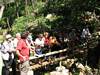
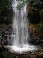
The Agua d’Alta Cliff is the largest existing waterfall in the Naturtejo Geopark and in all of the Beira Baixa, in the Agua d’Alta River, with a drop of 50 metres followed by a succession of 3 veils of turbulent water. It is possible to observe it up close and from the lookout point located at the top of the waterfall at Cabeça Murada. Alternating layers can be seen with different degrees of resistance to erosion, metric embankments of quartzite alternate with decimetric embankments of quartzite and pelites, less resistant to the fluvial wear. Erosion occurred in a differential manner and affected the less resistant layers. Over time a lithological cliff composed of three quartzite bars was formed. The richness of this location is increased due to its important biodiversity, including remnants of Laurissilva which covered SW Europe before the glaciers and which currently only exist in a few rare locations, such as for example the shrub (Viburnum tinus) and one of the largest populations of the laurel (Prunus lusitana lusitana) which still remains in the world. Another way to explore this location, as well as the other sites of the Serra do Moradal, is by means of the Orvalho GeoRota.
CHARACTERISTICS
LOCATION
Address: Orvalho (nearby)
City: Orvalho (nearby)
Postal Code: 6185 - 000
Telephone: 272320176
Email: geral@naturtejo.com
Website: http://www.naturtejo.com
City: Orvalho (nearby)
Postal Code: 6185 - 000
Telephone: 272320176
Email: geral@naturtejo.com
Website: http://www.naturtejo.com
FUNCTIONING
Public venue, with no timetable or entrance fee.
ORGANISATION OF THE VISIT
The visit to this Point does not require prior booking and can be done individually.
Specific Conditions:
Guided tours are charged in accordance with the number of participants.
Method:
On foot
Difficulty Level:
Low
Group Visits:
Yes
Minimum Number of Person per group:
2
Maximum Number of Person per group:
0
Observations:
Through advance scheduled reservations.
Guided Tours:
Yes
Observations:
Through advance scheduled reservations.
EXISTING EQUIPMENT
Geological curiosity
GEOLOGICAL / MINING INTEREST
History Patrimony:
-
Activity Program:
-
Study and Research Unit:
-
Audiovisual and Multimedia Resources:
-
Volunteering Programs:
-
-
Activity Program:
-
Study and Research Unit:
-
Audiovisual and Multimedia Resources:
-
Volunteering Programs:
-
EDUCATIONAL SERVICE
Activity Description:
Educational programs in the Geopark Naturtejo are available in www.naturtejo.com. The program "Searching for Waters" begins in a spring of clear water, The Penedo Mijadouro, where some studiy and experiences can be done. Students are impressed by the Fraga de Água d'Alta, a marvelous waterfall. To know better the Ribeiro de Água d'Alta valley, one should follow part of the Orvalho GeoRoute.
Target Audience:
Teachers and students from all levels of education
Activity Cost:
3.5€
Weekly Schedule:
From 00:00:00 to 00:00:00.
From 00:00:00 to 00:00:00.
Weekend and Holidays Schedule:
From 00:00:00 to 00:00:00.
From 00:00:00 to 00:00:00.
Exceptions:
Educational programs in the Geopark Naturtejo booked in advance in: programas_educativos@naturtejo.com. Minimum fee 3,50€. The price varies with the optional choice of sports activities in nature.
Observations:
The approach to teaching content, adapted to various levels of education, is performed by Geopark Naturtejo’s monitors that present the scientific-pedagogical education qualification in the field of Geosciences.
EXTERNAL SUPPORT
Where to Stay
http://www.turismodocentro.pt/guiaalojamento.pdf
Where to Eat
http://www.cm-oleiros.pt/conteudos/65/98/restaurantes-do-concelho/
Security Forces
http://www.portaldasaude.pt/portal/servicos/prestadoresV2/?providerid=388
Cultural Facilities
http://www.cm-oleiros.pt/conteudos/6/29/biblioteca-municipal/
TRANSPORT
Type of Transport:
T. Rodoviário
Agency Name:
Rodoviária da Beira Interior
Telephone Number:
272340120
Parking for private vehicles:
Yes
T. Rodoviário
Agency Name:
Rodoviária da Beira Interior
Telephone Number:
272340120
Parking for private vehicles:
Yes
SITES OF TOURISTIC INTEREST
Aldeia de Xisto de Álvaro
A aldeia de Álvaro estende-se ao longo de uma encosta do Rio Zêzere junto da albufeira do Cabril. Rica em património religioso, esta localidade indicia uma grande importância para as ordens religiosas. Torna-se então indispensável fazer a Rota das Capelas para melhor conhecer esta aldeia. Para momentos de lazer, dispõe de um maravilhoso miradouro junto da Igreja Matriz e ainda de uma piscina flutuante na albufeira do Cabril.
gps: 39.97485 -7.96402
distance: 40km
Igreja Matriz de Oleiros
O início da sua construção data de 1532 porém, demorou tanto a ser totalmente terminada que foi alvo de reparação em 1715, antes de estar concluída! De entre o seu património, destacam-se os painéis cerâmicos figurativos que revestem as paredes laterais retratando uma cena profana e a expulsão do Paraíso; e os cinco altares existentes que preservam ainda o esplendor de outrora.
gps: 39.91703 -7.9135
distance: 35km
Aldeia de Isna
Apesar de não integrar a rede das Aldeias de Xisto, é esta a pedra que predomina nas suas casas, proporcionando-lhe em conjunto com a sua paisagem envolvente um panorama lindíssimo. Destaque para a Fonte das Mulheres, mandada construir pelo Rei D. Carlos que por aqui passou e atendeu os pedidos das mulheres da aldeia.
gps: 39.84189 -7.86033
distance: 46km
ASSOCIATED ROUTES
Geoparks in Portugal
Geoparks in Portugal UNESCO World Geoparks are territories with locations and landscapes of international geological importance, which combine the protection and promotion of its heritage with sustainable development. They are unique places where the oldest memories are millions of years old and include key locations that testify to the evolution of our planet. These territories are classified by UNESCO under the International Geosciences and Geoparks Program. Spread across all continents, geoparks are much more than areas of heritage relevance. They are dynamic territories of which local communities are part, where nature, history and culture are intertwined. There are currently 5 UNESCO World Geoparks in Portugal: Naturtejo (2006), Arouca (2009), Azores (2012), Terras de Cavaleiros (2014) and Estrela (2020). The Geopark on the coast of Viana do Castelo is preparing the future application, but its level of implementation in the territory, namely the educational offer it already develops, led to its inclusion in the GUIDE OF THE PORTUGUESE GEOLOGICAL AND MINES SITES, naturally without the status that UNESCO gives to the remaining territories. On the other hand, new applications are being developed, with several projects in the Oeste, Algarve and Figueira da Foz, which in due time may have their presence on this platform. To visit Portuguese geoparks is to embark on a journey that began 600 million years ago, when Portugal occupied a very different place on the globe, going through incredible episodes of formation and destruction of mountains and seas, of the appearance and extinction of species, of the occurrence of deep climate change, major volcanic eruptions ... until today in the relationship between man and the planet On this GUIDE the visitor will find a proposed itinerary to visit the most significant points in each national geopark, including, of course, the one located in the Autonomous Region of the Azores. Take a "good trip" on the GUIDE OF THE PORTUGUESE GEOLOGICAL AND MINES SITES and discover the interesting places we introduce you throughout the country.
Geoparks in Portugal UNESCO World Geoparks are territories with locations and landscapes of international geological importance, which combine the protection and promotion of its heritage with sustainable development. They are unique places where the oldest memories are millions of years old and include key locations that testify to the evolution of our planet. These territories are classified by UNESCO under the International Geosciences and Geoparks Program. Spread across all continents, geoparks are much more than areas of heritage relevance. They are dynamic territories of which local communities are part, where nature, history and culture are intertwined. There are currently 5 UNESCO World Geoparks in Portugal: Naturtejo (2006), Arouca (2009), Azores (2012), Terras de Cavaleiros (2014) and Estrela (2020). The Geopark on the coast of Viana do Castelo is preparing the future application, but its level of implementation in the territory, namely the educational offer it already develops, led to its inclusion in the GUIDE OF THE PORTUGUESE GEOLOGICAL AND MINES SITES, naturally without the status that UNESCO gives to the remaining territories. On the other hand, new applications are being developed, with several projects in the Oeste, Algarve and Figueira da Foz, which in due time may have their presence on this platform. To visit Portuguese geoparks is to embark on a journey that began 600 million years ago, when Portugal occupied a very different place on the globe, going through incredible episodes of formation and destruction of mountains and seas, of the appearance and extinction of species, of the occurrence of deep climate change, major volcanic eruptions ... until today in the relationship between man and the planet On this GUIDE the visitor will find a proposed itinerary to visit the most significant points in each national geopark, including, of course, the one located in the Autonomous Region of the Azores. Take a "good trip" on the GUIDE OF THE PORTUGUESE GEOLOGICAL AND MINES SITES and discover the interesting places we introduce you throughout the country.
SUGGESTIONS OF THE ROUTE- OTHER NEARBY PLACES TO VISIT
Panasqueira Mines Crystal Shop
Shop which offers exclusive selection of minerals and products from the Panasqueira Mines.