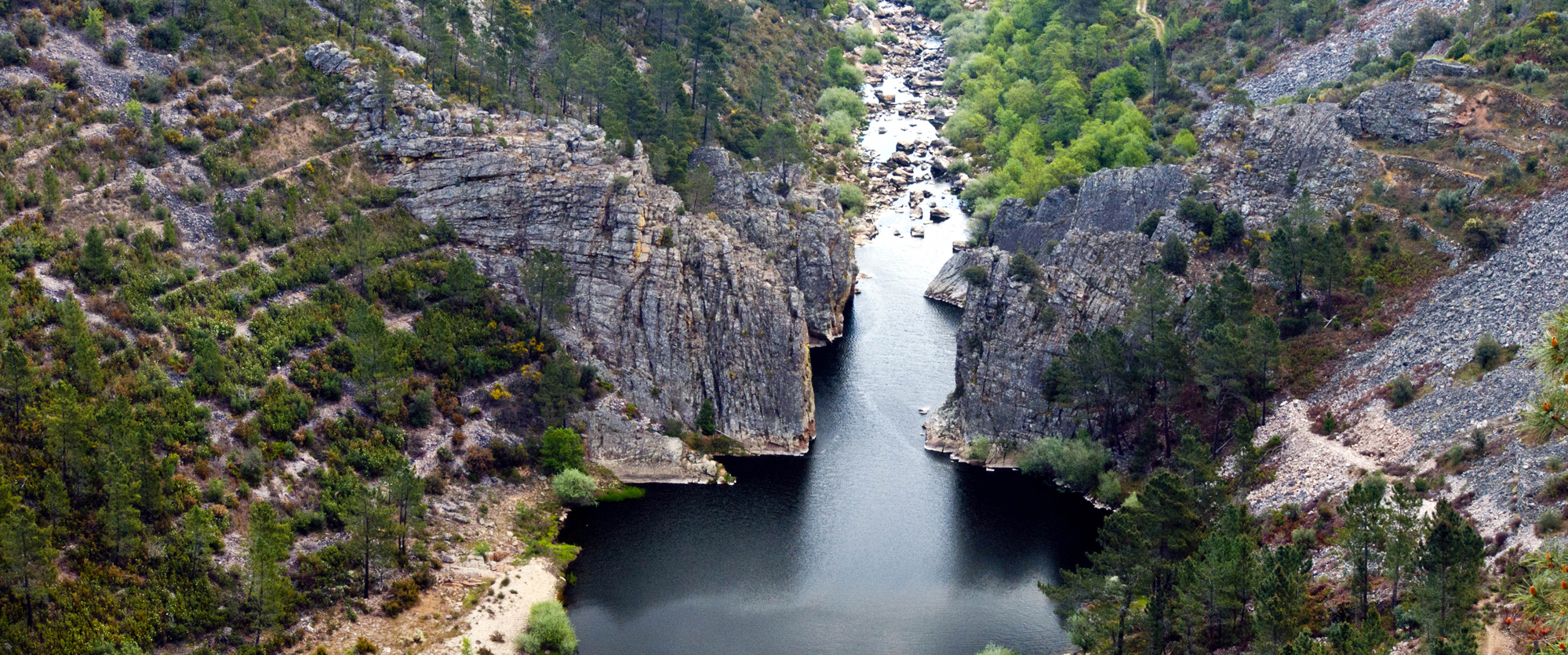
Portas de Almourão Geomonument, Foz do Cobrão/Sobral Fernando
Portas de Almourão Geomonument is an enchanted place where Ocreza disembowelled the intensely deformed quarzite cliffs with its erosive force over time. From the lookout points it is possible to see the Foz do Cobrao and the Sobral Fernando (thematic lookout points). The Portas de Almourão are comprised of an impressive throat which has been excavated by the Ocreza River during the last two million years, and divides the Talhadas Mountains into two powerful quartzite crystals. Walking through this saddle of 400m of depth is to make a journey through time, back almost 500 million years, up to a period in which the hard quartzite was made of fine sands deposited on the bottom of a vast ocean. A continental mega collision and 140 million years were needed for this deformation, to erect them from the bottom of the oceans to the most elevated peaks of these mountains, over more than 300 million years ago. 250 million years of chemical alterations of the rocks and erosion configured the Almourão region into the colossal landscape that we can appreciate today. In this location the silence of the geological convulsions from other eras is only interrupted by the flight of a griffin. In addition to the diverse lookouts from which to observe the geomonumnet, there are foot trails related to the "Schist Path." Flight of the Griffin", "Secrets of the Almourao Valley" and "Trip to the Bones of the Earth."
CHARACTERISTICS
City: Foz do Cobrão/Sobral Fernando
Postal Code: 0 - 000
Telephone: 272320176
Email: geral@naturtejo.com
Website: http://www.naturtejo.com
Specific Conditions:
-
Method:
-
Difficulty Level:
Low
Group Visits:
Yes
Minimum Number of Person per group:
2
Maximum Number of Person per group:
0
Observations:
Through advance scheduled reservations.
Guided Tours:
Yes
Observations:
Through advance scheduled reservations.
-
Activity Program:
-
Study and Research Unit:
-
Audiovisual and Multimedia Resources:
Folder "Foz de Cobrão: the village that once was an ocean"
Volunteering Programs:
-
Educational Programs in the Geopark Naturtejo are available in www.naturtejo.com.
Target Audience:
Teachers and students from all levels of education
Activity Cost:
5€
Weekly Schedule:
From 00:00:00 to 00:00:00.
From 00:00:00 to 00:00:00.
Weekend and Holidays Schedule:
From 00:00:00 to 00:00:00.
From 00:00:00 to 00:00:00.
Exceptions:
Educational programs in the Geopark Naturtejo booked in advance in: programas_educativos@naturtejo.com. The price varies with the optional choice of sports activities in nature.
Observations:
The approach to teaching content, adapted to various levels of education, is performed by Geopark Naturtejo’s monitors that present the scientific-pedagogical education qualification in the field of Geosciences.
http:// http://www.turismodocentro.pt/guiaalojamento.pdf
Where to Eat
http://www.cm-vvrodao.pt/principal.php?cont=8&sub=29&letra=p&lg=1
Security Forces
http://www.portaldasaude.pt/portal/servicos/prestadoresV2/?providerid=390
Where to Eat
http://http://www.cm-vvrodao.pt/principal.php?cont=8&sub=29&letra=p&lg=1
Where to Stay
http://www.turismodocentro.pt/guiaalojamento.pdf
Security Forces
http://www.portaldasaude.pt/portal/servicos/prestadoresV2/?providerid=393
Cultural Facilities
http://www.cm-vvrodao.pt/principal.php?cont=7&letra=p&lg=1
T. Rodoviário
Agency Name:
Rodoviária da Beira Interior
Telephone Number:
272340120
Parking for private vehicles:
Yes
This village gives us the true definition of a village, surrounded by farm animals and ell-son vegetable gardens. The Community Oven still orks today and the products made there can be purchased at the villages (Loja da Aldeia).
gps: 39.75122 -7.85342
distance: 14km
Living Science Centre of Florest
The Living Science Centre of Florest is a privileged place here it is possible to touch, experience, discover, imagine, learn about the forest and its resources.
gps: 39.73056 -7.86306
distance: 17km
Olive Oil Press
It is a monument devoted to the olive oil that documents all the historical phases of the production. Starting ith the use of human and animal energy to the use of hydraulic and mechanical force, it presents a territorial perspective of olive oil.
gps: 39.65418 -7.66944
distance: 16km
Castle of Rei amba
Rising on one of the cliffs of the Tagus River, the Castle of Rei amba is an ancient building that dates from the 7th century and that itnessed historical events such as the Seven Years' ar or the 1st French Invasion.
gps: 39.6438 -7.68803
distance: 18km
Geoparks in Portugal UNESCO World Geoparks are territories with locations and landscapes of international geological importance, which combine the protection and promotion of its heritage with sustainable development. They are unique places where the oldest memories are millions of years old and include key locations that testify to the evolution of our planet. These territories are classified by UNESCO under the International Geosciences and Geoparks Program. Spread across all continents, geoparks are much more than areas of heritage relevance. They are dynamic territories of which local communities are part, where nature, history and culture are intertwined. There are currently 5 UNESCO World Geoparks in Portugal: Naturtejo (2006), Arouca (2009), Azores (2012), Terras de Cavaleiros (2014) and Estrela (2020). The Geopark on the coast of Viana do Castelo is preparing the future application, but its level of implementation in the territory, namely the educational offer it already develops, led to its inclusion in the GUIDE OF THE PORTUGUESE GEOLOGICAL AND MINES SITES, naturally without the status that UNESCO gives to the remaining territories. On the other hand, new applications are being developed, with several projects in the Oeste, Algarve and Figueira da Foz, which in due time may have their presence on this platform. To visit Portuguese geoparks is to embark on a journey that began 600 million years ago, when Portugal occupied a very different place on the globe, going through incredible episodes of formation and destruction of mountains and seas, of the appearance and extinction of species, of the occurrence of deep climate change, major volcanic eruptions ... until today in the relationship between man and the planet On this GUIDE the visitor will find a proposed itinerary to visit the most significant points in each national geopark, including, of course, the one located in the Autonomous Region of the Azores. Take a "good trip" on the GUIDE OF THE PORTUGUESE GEOLOGICAL AND MINES SITES and discover the interesting places we introduce you throughout the country.


